Any comments or corrections can be emailed to thefireonthehill at gmail dot com.
This site is an attempt to look at the recorded history of a very small area, and to show that all places, no matter how ordinary they might seem today, have a rich and interesting past. Social history is after all only what happens wherever people have lived, worked, and shaped their environment. Even the most rural landscapes are often the result of centuries of effort. Every hedge and stone may have been placed there by the hands of people long since forgotten; every tree may have been planted or nurtured by someone. Boundaries, pathways and roads might hint at old ownership disputes, legal cases, and a hundred other stories which are now difficult to trace.
The township of Brymbo, according to its traditional boundaries, occupies an area of north-east Wales between the town of Wrexham and the outlying hills of the Welsh mountains. As you can see from the map below, originally drawn (to a scale of 2 miles to 1 inch) by the preeminent figure in study of Wrexham’s history, Alfred N Palmer, the township is no more than a couple of miles across at its widest.
The oldest of the area’s administrative divisions, Offa’s Dyke, runs right across it. The Dyke originally marked the frontier of the kingdom of Mercia, and the traditional limit of Saxon authority, but the township boundaries seem more recent, though it is still scattered with names of English origin. In the west, it stretches out towards the bleak common land of the moors above Minera, while its boundaries to the north, south and east are natural ones: the Nant y Ffrith stream in the north, the Afon Gwenfro in the south and a small brook (later known as the Lodge Brook, but long since disappeared into culverts) running into the Gwenfro in the east.
A lot has been recorded within these boundaries even before the Industrial Revolution. But the name The Fire on the Hill refers to events of over two hundred years ago, when a man named Wilkinson chose the area as the ideal site for a new ironworks and furnace; if there was ever a point at which the future character of a place was radically shaped, this was probably it.
It’s worth remembering that whenever “Brymbo” is referred to on this site, it will be in the context of the old township boundaries unless stated otherwise. This includes areas, such as Glascoed, Bwlchgwyn and Pentre’r-fron, which are outside the boundaries of the modern village of Brymbo. The area occupied by the latter was, before the early 19th century, more usually called Harwd or Harwood. Similarly, the township area does not exactly coincide with the ecclesiastical parish of Brymbo, which was created only in the 1830s – although confusingly enough it does coincide with the civil parish, which is more or less identical to the old township.
You can access the content of this site via a regularly updated index of places, a rather less regularly updated timeline, by browsing the categories on the left, or simply by looking at the archives for each month.
Other sources

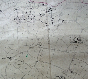
From the Brymbo tithe map of around 1840. At the top centre is the village then often called Harwood, after the common it was sited on.
Anyone reading about the area’s past would do well to start with the work of Alfred Palmer, particularly the chapter on Brymbo in his 1903 book The History of the Thirteen Country Townships of Wrexham (there are also useful chapters on Minera, Esclusham and Bersham). Unfortunately this is one of the hardest of Palmer’s books to obtain, being available only as a first edition or a rare and expensive reprint. You can, however, consult copies in the Denbighshire Archives, Wrexham Library, or (appropriately enough) in Wrexham’s Palmer Centre. This contains a large amount of information, usually very accurate and detailed, though I’ve since found some mistakes in it.
Palmer’s similar work on the parish of Gresford, which includes a chapter on Brymbo’s neighbouring township of Gwersyllt, is now available via a digitised copy of Archaeologia Cambrensis on archive.org. Gwersyllt is described from pages 179-196.
John Wilkinson’s life is well covered by articles on the Broseley History Society’s website (in the links to the left).
If you would like to read about the more recent history of Brymbo – by which I mean the early 20th century – the main source is probably Graham Rogers’ book Brymbo and its neighbourhood (1991, ISBN 978-0707402055), which contains some interesting reminiscences.
The steelworks itself is covered by Ioan Jones’ Brymbo Steel Works, a collection of pictures (ISBN 1-872424-13-9). Bridge Books have published a number of other books on local history, including reprints of Palmer’s work.

