You are currently browsing the category archive for the ‘Bwlchgwyn’ category.
Stones, along with hills, valleys and springs, provide some of the most persistent place names we have; trees and people come lower down the scale of permanence. Both naturally-occurring rocks and deliberately placed ones were also often used as boundary markers for parishes and townships, their status underlined by a yearly walk around the boundary points by a group of residents (along with their children, who would have to perform the same duties themselves one day). As disputes over boundaries and land rights were a regular feature of rural life, it was helpful to know exactly who was responsible for what.
The boundaries of Brymbo township mostly follow natural watercourses, so that was simple and uncontroversial enough. Things were slightly less certain on the common moor above Bwlchgwyn, but the responses of the local freeholders to Norden’s Survey, in 1620, shows that they had not really bothered to find out the boundaries there, which would not become a serious consideration until the land began to be enclosed. In adjacent townships, various markers appear: Norden describes the boundary of the township of Burton, where it met the parish of Hope, as running to “a place where the hoare wythen did grow neere the common Moore“. Boundary stones might also have been used, as he notes the boundary of Esclusham as proceeding “through certaine ffeildes with certaine markes knowne“. Even if not used as boundary markers, there were, however, a number of named stones or rocks dotted about Brymbo township – some natural and some perhaps set there by human agency in the distant past.
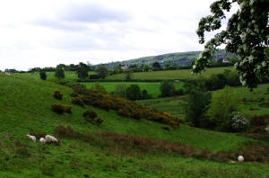
Rough pasture near Ffynnon-y-cwrw. This land was first added to Brymbo during the 13th century creation of Minera: the more fertile fields in the distance are in Minera township, along with the slopes of the mountain once called ‘Glasfre‘.
The upper and western part of the township of Brymbo is formed of land that was once mainly mountain “waste” or common. Although the higher parts are still open, much of the area is now either enclosed as rough pasture or has become part of the village of Bwlchgwyn. Two familiar processes can be seen at work here: the piecemeal encroachment onto common land of labourers’ cottages and gardens, and the efforts of 18th and 19th century ‘improving’ landowners such as John Wilkinson and James Kyrke. However, in the case of Brymbo there is an extra element in the area’s long history of mineral extraction: it is even to some degree responsible for the physical boundaries of the township as they later appeared.
The “waste” seems a bleak place today, friendly only to sheep and grouse, but it is even now scattered with the signs of Bronze Age habitation, and was hardly deserted in mediaeval times. Some areas would have been wooded, perhaps frequented by the charcoal burners often associated with the early appearances of the name “coed poeth“. As common land, the waste would have been a rich source of game (Norden notes that the upper reaches of Esclusham manor were much frequented by gentlemen with their hawks) and defined areas within it, later becoming detached parts of Esclusham township, were reserved as summer pasture for Valle Crucis and for the lord of Bromfield. Throughout the summer months the area would have been covered with livestock and the huts or hafodau of the shepherds who looked after them. In the autumn, however, the cattle were withdrawn to farms on the lower slopes, and the higher ground was largely left to the snow and perhaps, in the earlier part of the period, to the wolves remembered in a handful of old field names. The freehold farms of Brymbo would, in this period, have been the last outpost of settlement before the beginning of the upland commons.
The late 18th and first part of the 19th century saw something of a fashion for travelogues covering the ‘wilder’ parts of Britain – which, after all, were then still uncharted territory for most of the reading public. There are a number of descriptions of journeys through north Wales, the greatest of which is also one of the earliest, that of Thomas Pennant; Pennant described Wrexham, but sadly mentions our own little area of study only briefly. At the other end of the period, Borrow – passing through in the mid 19th century – talks about the miners of Minera and Ruabon, in generally uncomplimentary terms, but fails to mention those of Brymbo. Nevertheless, one or two books have taken notice of the area over the years.
One of these books was called Cambria Depicta, published in 1816, the work of a painter from Ruthin called Edward Pugh. Landscape prints were an even bigger industry than travel literature during this period, and Pugh’s ambitious work – Cambria Depicta took over nine years to complete – combined handsome colour plates of his sketches with a lively narrative of his travels around north Wales. He did not, in fact, live to see book published, dying in 1813 three years before its publication. It has never been reprinted and was very rare even a century ago, but I was recently very fortunate to be able to look at a copy, as almost alone amongst books of the period it includes a few pages describing a day spent in and around Brymbo. It is usually only mentioned in connection with one of Pugh’s pictures, which shows the Ffrwd canal in water with Caergwrle castle in the far distance, but deserves to be better known.

The township road at Ffynnon-y-cwrw, looking East
The old “township road” of Brymbo, once maintained by residents’ contributions in a time before the modern highway system or even the turnpikes, is still called the Brymbo Road today. In a previous post I followed it from the site of Brymbo Hall through Penrhos to the crossroads at Pentresaeson: from here it runs west, towards Bwlchgwyn.
Leaving the crossroads and the Smelt Wood behind, the road passes the former Taylor Brothers foundry and Pentresaeson farm on the right and crosses the line of the railway from Brymbo to Minera. Here it climbs steeply under a deep bank that is covered with bluebells in spring. The road keeps just within the township border – marked by the Gwenfro, out of sight to the left – as it approaches the moor that was once another part of Brymbo’s common land.
Bwlchgwyn is the ‘second’ village of the old township of Brymbo. It is supposed to be the highest village in Wales, and whether this is true or not, it certainly has some of the finest views, facing eastwards towards the flatlands of the Maelor and Cheshire and with its back to the fierce weather blowing over the hills.
As a settlement, in the modern sense, it is no older than Brymbo village itself and possibly much less so (though the moorland farm called Craig-Corn appears well back in the 18th century, when the Foulkes family tenanted it). One of the township’s main commons once surrounded the site of Bwlchgwyn, and it seems quite possible that like many such villages, it may have grown around small cottages and holdings encroaching onto the common land. Palmer suggests that the old one-night house custom was in operation in the area; if this was really the case, it is likely that the quarrymen and miners of the township would have carved small plots out of the common. According to Palmer, it also seems possible that this was the area of the township where its inhabitants cut turves, the common turbary: the name “the Gorse”, applied the nearby farm which was created out of common land by John Wilkinson in the late 18th century, may indicate this.
